Monday, March 28, 2005

Auwe, another great Temblor:

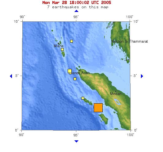
A large (Mw=8.2) earthquake occurred off the western coast of Northern Sumatra today, and tsunami warnings were issued in nearby Thailand.

The quake struck at about 11:10 PM local (11:10 AM EST), and was about one fiftieth as strong as the December 26 event. The hypocentre was about 30 km (+/- 6.1 km) deep, and was followed by a Mw 6.0 aftershock within about 30 minutes, offset to the South-East. It is not known at present whether these events produced tsunamis, but the rapid Moment Tensor Solution for this event shows an almost vertical motion for the event.


Another Indonesian earthquake today... Posted by Hello

Friday, March 25, 2005

Spongebob's neighbourhood:

Who said science wasn't funny?

Here's Squidward's cousin, Octopeter marginatus, hoofing it (suckering?) across the Indonesian seafloor.

And Octopaul aculaeatus, looking a little frazzled, wanders away from the party...

(videos require the RealPlayer plug-in)

OK, ok, here's the whole story...grab onto it with all your arms & legs.

Wednesday, March 09, 2005

Why for you bury me in the cold, cold ground?

...a statement which Taz could be asking very soon, but not of Bugs Bunny.

An article in Science (Vol 307, Issue 5712, 1035, 18 February 2005, summary) recently drew my attention to something that has bothered me for years.

For some reason, probably to do with the context in which I learned the word, a disease has always seemed to me to be something that was communicable, or that at least had some kind of vector. So things like leprosy, measles, malaria, influenza were diseases, while things like cancer, diabetes, Krohn's etc. were not. I would have called these latter things 'conditions.'

I now know this is not how they are defined medically, and that there is probably medical or epidemiological terminology to describe exactly the kind of separation I describe above, and that I still feel echoes of today when I hear the word 'disease' used to describe things that cannot be transmitted from one individual to another.

...or am I sure? The Science article describes a facial cancer that has been observed to be increasing in frequency among Tasmanian Devils. The disfiguring facial cancer eventually grows so large that it interferes with the creature's feeding, and they starve to death. The point in the article that stunned me was that this cancer seems to be spreading because the Tasmanian Devils are in fact spreading cancerous cells to each other as a consequence of the vicious fights they normally enage in, including biting each other's mouths. In other words, this is a cancer that is a communicable disease. Evidently these cancer cells can get around the self/non-self signals that are the basis for most immune systems. This is a cell that is not exactly some other form of life, but a mutated version of self.

I think this is more evidence that Nature loves these grey areas, and always holds a surprise, like a sort of fractal.

Tuesday, March 08, 2005

Farewell to a Trojan:

Earlier last year we said good-bye to a real workhorse of an airplane. This airplane was 55 years old, and had lived a hard life. How hard? Well, consider repeated, deliberate flights into the worst weather possible: thunderstorm supercells full of tennis-ball sized hail (full of super-cooled water, which means icing), repeated lighning strikes, and turbulence unlike any of us has experienced, even on the worst rollercoaster. Sounds like a fun piloting job!

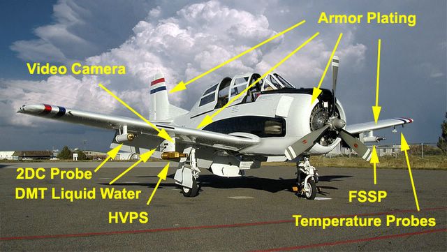
The ariplane was N10WX, a highly modified T-28 Trojan (WX is a common abbreviation for 'weather'). In the early 1960's the South Dakota School of Mines and Technology's Institute of Atmospheric Sciences began operating this bird as a scientific research platform, and until early 2004 flew it hundreds of times into storms that other pilots would take every possible precaution to avoid. Why choose a 1950's trainer in the 1960's, and operate it this long? Several reasons. First, it had a piston-driven prop rather than a turbofan - jet engines don't do so well in heavy hail, stalling and being unable to re-start. Second, it had a airframe strength/engine power combination that could support two heavy items: armor plating and a thick coat of ice. Third, that airframe was designed to withstand a lot of punishment (think keeping student pilots safe...). And fourth, there were a lot of them available for a good price (over 2200 were built - the other choice was the Douglas Dauntless, but purchase cost and maintenance ruled it out).

Here's a picture of the T-28, with some of the features pointed out:


Armored T-28 Posted by Hello

Of course, there are many more instruments and hard points for mounting them than shown here. The 700 lbs of armor plating is on all the tops and leading edges of the wings and the rudder and the radial engine cowling, and of course the canopy is also armored - the original plexiglass 'bubble' would never survive!

Here's the kind of damage the hail does - this is a shot of the wing-tip, and you can clearly see the difference that the armor plating makes - the original aluminium wing covering is severely battered, while the armor does not show any damage.


T-28 wingtip Posted by Hello

There are several other areas that are heavily armored - the air intakes for the carburetor and for the oil cooler.

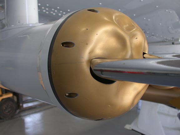
Of course, anything that stuck out was either going to get hammered or struck by lightning. What would usually be somewhat delicate instruments on other aircraft had to be modified (I wonder what the Pitot looks like on this thing?). Here's a shot of a detector with a somewhat crumpled dome...


instrument Posted by Hello

My first thought on seeing these pictures was that it must have been incredibly LOUD in the cockpit. Not only were you riding a 1425 hp Wright Cyclone at several hundred knots, but the noise from the hail must have beed absolutely deafening, mixed in with the occasional lightning strike (which resulted in pieces melting off the trailing edges of the prop and rudder!).

Now that it has been retired, the School of Mines is in contact with the Smithsonian and others to see if anyone is interested in exhibiting N10WX. And of course, the scientific community is looking for another platform that can take this kind of punishment and keep the pilot safe. The candidates so far: an Air Force A-10 Thunderbolt "Warthog" (but chances are not good for an A-10 being released, given the current operations needs for both active ariframes and spares...); or a Coast Guard HU-25 Falcon. Both of these of course are turbofans - it will be interesting to see how the replacement holds up over 50 years of service - if they even make it that long.

The long-time pilot for the T-28, Tom Warner, has a nice homepage for the airplane here (as well as having some great WX photos that deserve a look!).

Sunday, February 27, 2005

Ward, Wieland, and Cialdini:

When I visited the petrified forest as a child, it was fairly obvious to me why it was prohibited to pick up pieces of the petrified wood - samples in pockets would wander off, and the whole monument would slowly disappear.

On that same summer road trip, I logically wondered if by taking samples from the Grand Canyon I would be a) degrading the natural wonder by removing some of it, or b) adding to its beauty, since the canyon exists precisely because material has been removed.

A few days ago we had a visitor here from the National Parks Service, and she related a story about the National Cycad Monument in South Dakota that reminded me of all this - the Cycad Monument was decommissioned in 1957 because there were no fossils left to see. The fossils had all walked off in visiting pockets.

The Park Service's best estimate for current losses from the Petrified Forest are about 25,000 pounds (!) a year. People are caught every day (some with hundreds of pounds stuffed under their car seats). The forest is such an attractive site for theft that it has been used as a test site for studying what kinds of warnings are most effective at discouraging theft. The best estimate is that about 3% of the visitors actually steal material.

When I first visited Hawaii in 1985 with Caltech's Bob Sharp as a tour guide, he regaled us with tales of "Pele's curse," whereby if anyone took a piece of the Goddess Pele home (a piece of Hawaiian pumice, basalt, green sand, etc. etc.), she would bring bad luck upon them. In the Bishop Museum and the Hawai'i Volcanoes National Park Museum there are plently of examples of tourists who mailed back their 'souvenirs' (even their sandy shoes, in one case), thinking that their streak of bad luck after their holiday was due to Pele's curse.

In any case, my long-winded point is that this type of "curse myth" seems to be popping up at other parks - the Petrified Forest is getting souvenirs returned as well.

Perhaps there should be a study done about the effectiveness of public announcements saying "if you take anything except pictures, you will have really bad luck."

And yes, I do have a piece of Pele in my house. It's not illegal to take pieces of lava from Hawai'i. It's a really nice chunk of frothy green pumice and some Pele's hair that I collected from the side of Chain of Craters road. And yes, I have had bad luck since then. Only I am quite sure that one thing has absolutely nothing to do with the other. And did I take a piece of the Petrified Forest or the Grand Canyon? I'm not sure. It was so long ago that I can't honestly remember - I do remember being very tempted, and if I did, I have since lost the pieces, which is probably the sad truth about a fair bit of the ton-a-month rate for the Petrified Forest.

Friday, February 18, 2005

We shall never forget:

A conversation I had several years ago with the Department of the Treasury's Office of Foreign Assets Control:

Science agency drone (me): "Hello. I have a question about financial transactions involving the Cuban government."

OFAC drone: "No financial transactions transferring funds to Cuba are allowed."

Science agency drone:"...yes, I am aware of that. In this case, Cuba is wanting to pay its membership dues to an international organization currently headquartered in the U.S."

OFAC drone: "No financial transactions transferring funds to Cuba are allowed."

Science agency drone:"...umm, I think you misunderstood. Cuba wants to send funds here. This is not a case of U.S. funds going to Cuba, but Cuban funds coming to the United States."

OFAC drone: "...huh. Well, then we would have to seize the funds as war reparations."

Science agency drone:"...war reparations? You mean, like for the Maine?"

OFAC drone: "Yes. For the Maine."

Science agency drone:"Wow. I'll tell them that they should consider being delinquent on their dues."

OFAC drone:"Yeah, I guess so. Have a good day."

Science agency drone: "You too. Bye."

Monday, February 14, 2005

The bells, master, the bells...

The Sumatra Andaman quake that generated the tsunami also made the Earth ring like a gong. Some of the tones last longer than others - the most fundamental frequency is still ringing, expanding and contracting the Earth radially, and should be detectable well into April.

We have to use very special techniques to see this, since the period for this harmonic is quite long - about 20 minutes. So it's really more like a very low groan than a ringing gong...

IRIS has a lot of info on this. Here's an audio file (.au format) of what it sounds like, speeded up about 200,000 times.

Monday, February 07, 2005

Tsunami science & fakery, and a bit of image analysis:

I just met with Jody Bourgeois, who is a sedimentologist at the University of Washington who studies tsunami deposits. We are interested in her work because while the tsunami genesis community has had a lot of attention and funding, the tsunami history community has not. In other words, we know a lot about how tsunamis are generated, but not a lot about how often they occur.

Jody works mostly in the Pacific (where most tsunamis occur, as you will have read in one of my previous posts), looking at the layer of rubble, gravel, sand and silt that tsunamis leave when they run up onto the shore. By digging pits in various spots, and looking at these layers, one can build up an idea of how often these events occur. Once you find a tsunami deposit, you can do a series of pits progressively farther from the shore to see how far the tsunami went inland - in this way she is trying to see where they occurred, how often, and how severe they were. Most of her work has been in the Cascadia region of the US (Washington state), and on the Kamchatka peninsula, in the Russian far East.

Here is a photo taken by one of Jody's grad students, Bretwood Higman, while in Sri Lanka on the tsunami survey team:
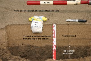

Tsunami deposit in Sri Lanka (photo credit: B. Higman) Posted by Hello

In this case, a 30 cm layer of lighter-coloured sandy tsunami deposits overlies the previous darker-coloured soil surface. Jody showed similar sections from the West coast with grey tsunami deposits sandwiched between the pre-existing soils and the later, younger soils on top of them (in the above photo, the younger soils overlying the tsunami deposit have not been deposited yet, since the tsunami occurred so recently).

As you might imagine, Jody is in great demand these days, and is in Washington DC to speak at a Smithsonian press event tomorrow morning at the Willard. She has been dealing a lot with public misconceptions about tsunamis, and she spoke to us about the threat to the Atlantic coast.

One item she mentioned was the threat from the cataclysmic collapse of the Cumbre Vieja volcano in the Canaries, much quoted in the press, and parroted by me here. It turns out that the model producing a 25 meter high wave on the East coast is a model by Steve Ward at UC Santa Cruz (you can see a set of Steve's powerpoints on landslide generated tsunamis here, including diagrams of the Cumbre Vieja predicted wave). Of course, disasters make for good news, so the work by Steve on the tsunami and by Bill McGuire of the Benfield Greig Centre in the UK on the collapse of Cumbre has been played up a fair bit by the press.

This much, at least, is still science. On to the outright fakery portion.

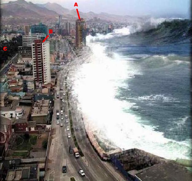
Immediately after the Sumatra event, all sorts of photos emerged purporting to be of the tsunami. Fortunately many of them were real, which can help educate people on what to do in this situation, and to document what happened. Others were outright fakes that only serve to propagate misconceptions. Jody used the following example in her talk that I had seen floating around on the internet, and which I had tried to stamp out as well as I could by telling people it was a fake (the red letters are mine, more below on that...).
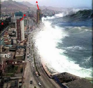

Fake tsunami photo Posted by Hello

I hadn't paid much attention to it in the last few weeks until I saw it again, up on the big projection screen, and it screamed out "South America" to me. I don't know exactly why, but something in the architecture, setting, etc. just made me think the city was in Latin America. At first I thought it was Bogota, because one of the buildings looks somewhat like the Tequendama Hotel, and a far off building looks like the Avianca skyscraper, but there were still several things wrong for the skyline to be Bogota.

A quick search on Snopes.com identified this tsunami picture as a known fake - and pointed to a what they claim as the source for the original photo of the Antofagasta skyline at World City Photos:
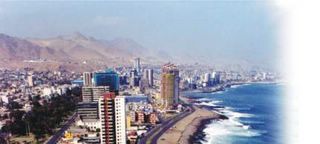
(c) Christian Lantadilla
Lantadilla photo, looking South Posted by Hello

Sure enough, this photo by Christian Lantadilla is of the same scene. However, I do not think this is the photo that was used in the fake.

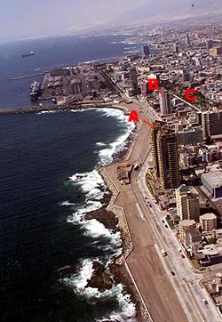
To confirm this, I did a bit more searching myself. First, are the two photos Antofagasta at all? Sure enough, there is a giveaway photo of the Antofagasta waterfront here, in an artcle in Realidad, a Chilean magazine. Here is the photo:
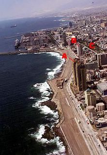

Realidad photo, looking North Posted by Hello

I have added letters to identify several landmarks. The fake tsunami and Lantadilla photos are taken looking South, with the city to the left. The Realidad photo is taken looking to the North. The letter "A" marks a tall building with yellow and red bricks with a characteristic roof shape. "B" indicates another building with characteristic red and white brickwork, while "C" indicates a park area.

But back to the difference between the tsunami and Lantadilla scenes of Antofagasta. As can be seen in the Realidad picture, it is very probable that the other photos were taken from the dark building at the end of the road just to the left of the "B." My guess is that these two photos were taken from different floors, at different times.

First, look at the mountains and the air and light surrounding them. The lighting and visibility is totally different between the two pictures, and this is not something easily changed with image processing - nor would there be a motive for the person faking the tsunami to put the work into changing the apparent visibility. The Lantadilla photo was taken on a clear, sunny day, while the fake tsunami background was taken on a more overcast, flatter lighted day. On the street next to the park there are tree shadows in the Lantadilla photo that are not present in the other (there is also a vehicle on this street in the tsunami picture that is not in the Lantadilla photo).

Second, the parallax in the photos is different. My guess is that the fake tsunami photo was taken from higher up, and more to the West (seaward), than the Lantadilla photo. It's difficult to tell with the images here, but if you download the originals, you can tell that the red & white brick building shifts ever so slightly against the more distant buildings behind it when you alternate between the two photos. You can see more of the roof (upwards motion) in the fake photo, and the red brick stripe moves leftwards against the building in the background (seaward movement of the observer). In this area there are several other inconsistencies - a possible reflection in the blue-glassed building that is either not there or due to intervening construction between the two photo times, and construction or modifications on the grey building that extends from the red & white to the park area.

I'm convinced that a) the tsunami photo is fake, b) the background is Antofagasta, and c) the fake was not made with Christian Lantadilla's photo.

In the end, what is wrong with the fake photo's water? Why couldn't this be a real tsunami in Chile? First is the scale - look at the height of that wave - it's taller than some of the apartment buildings. Only a major asteroid impact would give that kind of height. A tsunami is a low wall of water that simply keep on coming - sort of like a step function, and not a tall curling wave. Second, the scale of the features in the wave is wrong - look at the ripples and the foam - they just look wrong compared to the size of the cars. Now - there have been tsunamis in Antofagasta, with 1995 being the most recent - but they NEVER looked like this. This is not what a tsunami looks like - at a distance, tsunamis look harmless enough for you to simply stand there and watch. ...and take photos. ...and wait. ...and film. ...and suddenly realize that there is a river of seawater coming for you!

I had to chuckle as I was putting this post together: "Realidad" is Spanish for reality, or truth.
Friday, February 04, 2005

Kahve:

An interesting legend about the beginning of Western use of coffee is that after the siege of Vienna in 1683, the retreating Turkish armies abandoned their coffee supplies and equipment on the field. To celebrate victory over the Turks, bakers made a special pastry in the shape of a crescent - today's croissant.

However pretty a story, this is probably not true. There is good evidence that coffee was present in Vienna and many other Western cities before the 1683 siege. I'm not sure about the croissants - I need to do more research (which of course, includes consumption!).

There is a good paper on the history of coffee here, that includes a debunking of the Vienna myth.

There's a nice page in English on Viennese coffee houses here.

Get a slice of Sachertorte to eat while you sip your Maragogype, sit down, and read.

Wednesday, February 02, 2005

Dynamite in his drawers:

Leon Lederman keeps his Nobel Prize in a kitchen drawer with all his other junk - rubber bands, twisted paper clips, odd pieces of string, a screw-driver covered in paint, Post-Its gathering dust on their sticky part.

We all know the drawer, because we have one too. We just don't have a Nobel Prize banging around in there.

Tuesday, February 01, 2005

Y los cuentos, cuentos son:

...after Calderon de la Barca.

As the figures for tsunami casualties climb, it is slowly becoming clear to people that there will never be an accurate count. In fact, thinking that there can ever be accurate counts for events like this is a fantasy.

As rational beings, we know that such a figure exists - the number of casualties, even if changing, is still a "countable set." However, the logistics of providing an absolutely accurate count quickly become unreasonable. Even in highly controlled situations, like voting for political office, an absolute count is extremely difficult. That is why such counts, to be understood and used for decisions, must have statistical qualifiers attached.

When dealing with situations where we are relying on eyewitness accounts, or even historical/oral accounts the unreliability of absolute numbers is well known. When dealing with emotionally or politically charged issues, this effect is even more pronounced. In fact, history itself can be changed.

In 1928, a strike at the United Fruit Company facilities in the city of Cienaga, Colombia, turned violent when Colombian forces tried to disperse the crowd. Shots were fired, and several strikers were killed. Accounts of the incident from the points of view of the strike leader, Alberto Castrillon, and the commander Cortes Vargas varied widely (as might be expected), and differed again from the later accounts of investigative lawyer Jorge Eliecer Gaitan and media reporters.

Casualty estimates ranged from single to double digits. The exact number of casualties became an issue, and the government was accused of trying to hide the real number.

Gabriel Garcia Marquez' father spoke of the United Fruit strike and riot before Colombian Congress in 1929, and must have spoken of it at home, because it made enough of an impression on the author for an event based on it to appear in his book "One Hundred Years of Solitude." In that story, the fictional town of Macondo loses over three thousand citizens to bullets and truncheons. Garcia Marquez amplifies the Cienaga incident into the Macondo massacre to make several points - to emphasize the military's brutality, to emphasize the influence the foreign company had on the government, to single out the surviving characters' roles in the town's history, and perhaps, to point out that accounts are unreliable and at some level are all fictional.

The crowning event is that at some point in the 1970's, this subject again came up before the Colombian Congress, and in sworn testimony that entered the public record, the number of casualties in the real Cienaga incident (not fictional Macondo), was stated as "over three thousand."

This was later corrected, but the damage had been done. For many people, this mistake became a government admission that several thousand had died in the Cienaga event.

Fiction had changed history. And only because a combination of emotion, writing talent, and confusion came together at a particular moment.

For this case there is a trail, but for how many other events has this happened without someone noticing? Not simply numbers of casualties, but perhaps the details of the events themselves.

Sunday, January 30, 2005

Adulation! Praise!

...well, faint praise at least. OK, well maybe it's just a link. But links are what bloggers crave.

It looks like ::dura:mater:: is being used again as an example of technical writing in a course that has students set up blogs. This time it's Douglas Eyman's WRA 110 'Writing About Science and Technology' at Michigan State University.

There are links on the page to some of the student blogs, which not surprisingly are better laid out and written than this one. After all, they are being professionally trained. And graded. I had an interesting surf through them.

Thursday, January 27, 2005

Tsunami threats in North America:

Excerpts from a recent Press Release on expert witness testimony before the House Committee on Science:

"Brigadier General David L. Johnson (ret.), Assistant Administrator of the National Ocean and Atmospheric Administration (NOAA) and Director of the National Weather Service (NWS), said that between 1900 and 2004, 923 tsunamis struck the Pacific Ocean, 120 of which caused casualties and damage. 'Furthermore, there was no single year during this period that was free of tsunamis,' he said.

Dr. Charles 'Chip' Groat, Director of the U.S. Geological Survey (USGS), told the Committee that there is a 10-14 percent chance that the Oregon coast will be hit by a tsunami comparable in size to the one that recently hit South Asia within the next 50 years."


While the current focus on tsunami threats is mostly in the Pacific because of the amazingly high frequency of tsunamis there (923 tsunamis in 104 years!), the threat to the Atlantic coast is just as real - although less frequent. Most of this difference in tsunami frequency has to do with how plate tectonics controls what happens at the edges of the two ocean basins.

Here's why: first, remember that the total surface area of the Earth does not change. This means that when seafloor is created somewhere (for example, at a mid-ocean ridge), then an equivalent area of surface has to be destroyed elsewhere. Surface is in fact destroyed in subduction zones (see the post below on the Asian tsunami for a diagram of subduction).

The Atlantic has relatively gentle tectonic activity on the mid-Atlantic Ridge where the seafloor is spreading, pushing the Americas away from Europe and Africa. The Pacific, on the other hand, is bounded by subduction zones, where a lot of seafloor is being destroyed. Subduction is a generally more violent process that generates the great earthquakes - 1960 Chile, Alaska 1964. Aside: subduction also creates lots of volcanoes, and this leads to the "Ring of Fire" that has been so often mentioned, and confusingly associated with tsunamis.

So - one can expect that each ocean's tsunami frequency from subduction earthquakes varies with the amount of subduction going on at the boundaries of that ocean. And that is the case: There are more of these types of tsunamis in the Pacific Ocean, less in the Indian, and even fewer in the Atlantic.

However, there are other sources for tsunamis. You could think of subduction-generated tsunamis as what happens when you tip a tray of water - but you could also dump something into the tray and cause a wave, set off a firecracker underwater, or hurl a ball into the tray. Many of you have probably seen video of the glacier disintegrating in a Greenland harbour that causes a massive wave, or the calving glacier that causes a wave that drowns several unfortunate spectators. Landslides fall into this category of sources, and in fact a landslide was the source of the highest tsunami wave witnessed, about 500 meters (!), on July 10 1958 in Lituya Bay, Alaska.

Landslide-generated tsunamis are the main threat in the Atlantic. There are several places being looked at as possible sources - the main one being the Cumbre Vieja volcano in the Canary Islands. It is quite common for volcanoes to split off large parts of their flanks, which then slide off, either very gradually, or very suddenly. If Cumbre were to let go suddenly, models indicate that a 10 to 25 meter high wave would reach the Eastern Coast of North America within a few hours. So much for Miami, Charleston, Washington, New York, Boston, Halifax, etc. etc.

The other landslide threat is the large pile of sediments that build up at the mouths of rivers, or at the edge of the continental shelf. There are large sediment piles long most of the East coast of the US, built up by the erosion of the Appalachian mountains - sonar surveys over the deeps just outboard of the shelf show several places where enormous landslides have spread out many miles onto the seafloor. The Albemarle-Currituck slide is thought to have occurred about 18,000 years ago, and almost certainly caused a devastating tsunami along much of the mid-Atlantic coast. The tsunami waves probably carried several miles inland, and certainly penetrated along the larger rivers and bays of the region.

Another source for tsunamis is an underwater explosion - the firecracker I referred to above. Just about everybody has heard about the August 1883 Krakatoa eruption, which generated a considerable wave in the Sunda Strait. The closest large town, Merak, faced a catastrophic 35 meter high wave. There is not much threat for this type of eruption for the volcanic islands in the Atlantic off the African coast. Wrong type of volcano.

The last threat (and this applies equally to all oceans) is from an asteroid impact. If something large does a belly-flop into the ocean, it causes a large wave. I have addressed the threats to Earth from these types of collisions recently, and they are minuscule.

The source of the next East-coast tsunami will be either a volcanic collapse or a submarine landslide. When? Maybe tomorrow. Maybe several thousand years from now. But it will occur someday.

Tuesday, January 25, 2005

Krulwich on NOVA:

Hmmm. Some good TV on tonight...

PBS is premiering NOVA's new show, scienceNOW, and there's even going to be a piece about booming sand, a topic which has appeared here before...

Tune in, kids!

Tuesday, January 18, 2005

Endurance of Opportunity:


Posted by Hello

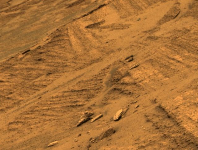
This is a picture of something any sedimentologist would recognize as a classic example of either cross-bedding or an angular unconformity (thanks to Ian Carr and Jackie Huntoon, who sorted out my misconceptions here...).

In cross-bedding, an advancing dune lays thin layers at an angle ('foresets') on its down-current face. This can be caused by either wind or water. The foresets are usually quite thin, and often occur in sets of sets, between bedding planes that are (or were) horizontal. Unfortunately, we can't see much lower - the section is buried in debris at the bottom.

In an angular unconformity, the lower layers (to the lower left in the frame) would have been laid down, tilted, and then eroded, cutting across the bedding (the diagonal discontinuity). The upper layers (in the upper right of the frame) were then laid down on top of this new surface. This is usually interpreted as physical evidence of at least tectonics and erosion, very possibly water-related.

These processes are common enough on Earth, but this is the Burns Cliffs inside Endurance crater on Mars. I'm amazed this didn't receive more press time than those incredibly cryptic "blueberries."

I'm sure that someone out there is doing numerical modeling of cross bedding for Mars, because there are a whole different set of physical constraints - different gravity, different viscosity of the air, windspeeds, etc. A lot of money has gone into this modeling for Earth, because of the oil industry, so there are probably a lot of starting points for budding Areologists...

Here is a (very large) image of some great soft sediment deformation - usually interpreted as a stream or river deposit, or at least a lake bottom with active slumping going on. The famous "blueberries" are quite prominent here - they were at first thought to be spatter from eruptions or impacts (like tektites), but some of their settings convinced the mission scientists that they were formed in place as concretions. Other physical evidence for water was the presence of vugs, or cavities where a crystal of some mineral deposited was later dissolved, leaving a hole.

It is very likely that similar cross bedding features exist on Titan, since there are liquids, winds, and enough body size for tectonics. However it is doubtful that we shall ever see them, since Huygens had no way to get around, much less usable battery power to do so. It was a feat just to get there and sit crippled on the surface while freezing to death.

...and yes, I feel sorry for the poor thing. I've felt sorry for them before (1, 2).

Monday, January 17, 2005

Zing!

Heard at a recent meeting:

Head of Programming for the Weather Channel: "What do you think about the future of the media?"

Head of Research, Xerox: "You will be out of business by 2010."

Friday, January 14, 2005

Cassini, Huygens:

Huygens is on the surface! Blocks of ice (?) litter the surface in this raw DISR image from the surface of Titan, 67 light-minutes distant from us. Luckily the lander was not toppled over and unable to point its uplink antenna... what I noticed was the rounded nature of the rocks. Also, very much like Mars, isn't it? Even with such different surface composition and temperatures!

ESA Cassini-Huygens website Posted by Hello

Cassini, Huygens:

First image of the surface of Saturn's moon Titan from the Huygens probe. Prominent are the dendritic drainage patterns that appear to head off to the upper left, and what appears to be a remnant crater in the center of the scene. The contrast between the light left and darker right side is not yet understood - perhaps even a shoreline with some islands, but the center of the scene is definitely a solid surface, upon which the probe appears to have survived at least two hours, transmitting data to Cassini above.

Image is a screen grab from NASA TV transmitting from ESA HQ in Darmstadt, Germany. Altitude of lander about 16.2 km, leading to a pixel size of about 40 meters. The quality is so bad that I am reminded of the Mariner Mercury shots... expect better quality soon. Posted by Hello

Wednesday, January 05, 2005

Watson & Crick:

...never dreamed of this.

On August 8 last year, a group of tourists were enjoying an afternoon aboard a Chicago Architecture Foundation tour boat. The Architecture River cruise takes a 90 minute ride along the Chicago River, viewing the details of over 50 famous buildings.

However, on this day, the tourists got more than they expected. As the boat passed under the Kinzie Street bridge, a passing tour bus emptied its bathroom waste tanks through the grating onto the helplessly upturned faces below. One hundred nine people, including several children and an infant, were showered with, um... sludge.

Surveillance cameras indicated a bus with characteristic markings was the only one to cross within 15 minutes of the incident, and descriptions from those passengers who could still see narrowed down the the bus to one chartered by the Dave Matthews Band.

The band was of course highly concerned, stated they were not on board at the time, that they trusted their long-time driver, and that they stood by his statement that he had nothing to do with the incident. In a public statement, the band members offered their DNA to prove that the offending items were not their droppings. The band later offered a $100,000 settlement for the passengers before results of the DNA test were divulged.

The case comes up before a judge next Friday, January 14th. There is no statement yet from the Illinois Attorney General's office regarding the results of the DNA test.

Moral - always be careful where you s#!t (or speak). Someone may carry it away and throw it for you. And it carries your characteristic stink, wherever it ends up.

Monday, January 03, 2005

von Muggenthaler:

My nuggets of learning today were:
  • Giraffes are not mute. We just assumed they were because we couldn't hear them. They emit sounds below our range of hearing.
  • Tigers emit infra-sound that can make you (and presumably their prey) go numb.
  • Cats purr in a range that promotes healing


My non-serious nugget is that Kyle the Kangaroo nearly beat out Tony the Tiger to be the Kellog's Frosted Flakes spokes-animal in 1952. Kyle must have been paralyzed during the reading by Tony's 18 Hz growl, which the casting director couldn't hear. I'll have to try growling really really low during meetings here and keep track of the results.
--
...not sure that worked. I just got a little more personal space as people backed their chairs away from me.
--
Now I'll try it in the subway. Tune in tomorrow.