A 'science highlight' I recently churned out for NSF:
Scientists at the National Center for Earth-surface Dynamics (NCED, http://www.nced.umn.edu/) have recently made a surprising link between topography and biological processes.
Working in the Angelo Coast Range Reserve in Northern California, Dr. Benjamin O’Connor (presently with the U.S. Geological Survey in Reston, VA), discovered that denitrification, a key nutrient process in streams, is controlled by the local landscape in and around the stream. It turns out that the combination of surface topography, the timing and volume of fluid flow and microbial processes all combine to produce areas and times of relatively high and low activity within the same stream, or “Hot Spots and Hot Moments.” Very small stretches of the stream can be responsible for much of the stream’s total loss of nitrogen to the atmosphere. This process is extremely important in watersheds where water quality downstream is of societal concern.
NCED has found that these Hot Spots can be predicted with a combination of high-resolution topography and hydraulic factors predicted from stream bathymetry. This work links to other discoveries showing that nitrogen and light availability affect the spatial distributions of algal blooms through the channel network, whereas recent flooding history determines whether the insects grazing on this algae will be vulnerable to predators like fish.
Advances such as these, coupled with highly resolved spatial data from remote sensing and other sources, provide a new basis for prediction in ecology.
Caption: Local topography controls denitrification “hot spots” such that ~80% of denitrification takes place in only ~16% of stream length in the Angelo Coast Reserve.
(Thanks to Chris Paola, Miki Hondzo, and Mary Power for corrections to the text...)
Thursday, February 22, 2007
Wednesday, February 21, 2007
A Stormy Past:
A 'science highlight' I recently churned out for NSF:
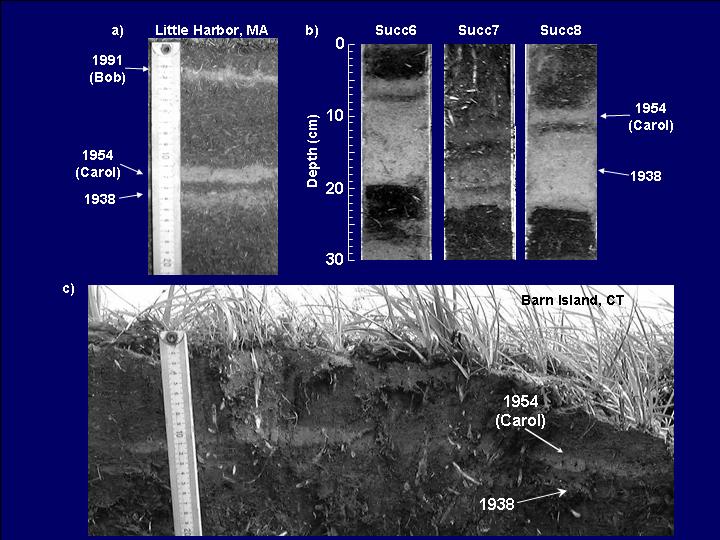
Scientist Jeffrey Donnelly, of the Coastal Systems Group at the Woods Hole Oceanographic Institution (WHOI), is looking closely at the mess left by hurricane storm surges--not the mess left by Katrina on the Gulf Coast, but the mess left in the New York City area. He has found not just one, but at least ten layers of sand left behind by likely hurricanes in the last seven hundred years.
Dr. Donnelly hopes to reconstruct the history of intense storms in the Southern New England and Long Island by looking at the deposits left by land-falling hurricanes and storm surges in backbarrier salt marshes and kettle ponds found at different heights throughout the area. So far, his group has found sand layers that correspond to the known great storms of 1991, 1954, 1938, 1893, 1788 and 1693 AD. Many additional layers indicate prehistoric storms that date back to 1642–1477, 1434–1347, 1316–1257, and even to 1190–1034 AD and earlier.
While considered rare in the New York City area, land-falling hurricanes have likely occurred many times throughout the past ~3500 years. With six severe storms, likely hurricanes, in the past 700 years, the frequency of land-falling hurricanes in the New York City area is equal to that of southern Rhode Island, and higher than that of southern New Jersey. Initial findings suggest that alternating periods of frequent and infrequent hurricane activity have occurred in the past, possibly tied to changes in climate. The times of high hurricane activity in western Long Island are 3500–3050 years before present (BP) and 2200–900 BP, nearly synchronous with high activity observed in the Caribbean and northern Gulf Coast.
Estimates of past storm strengths and frequencies are extremely valuable to researchers trying to tease out the influence of human activities on climate.
Sunday, February 18, 2007
Going in (Great) Circles:
On a spheroid like the Earth, it is a well known fact that the shortest path between two points lies on a Great Circle. What is not so well known is that this same Great Circle also defines the longest distance between those two points. The longest distance is simply the arc going the other way.
So, my question was: "what is the longest great circle route one could fly on Earth and always be over a) land, and b) water?"
Thanks to Google Earth and its Ruler/Path tool, I found the following candidates:
Over Land: Beach near Dong Hoi, Vietnam to Dakar, Senegal - 12,900 km
Over Water: Tellicherry, India to Iliamna Bay, Alaska - 29,000 km
You will note that for the overland route, I did not count small lakes as being over water. The key to this route is threading the arms of the Red Sea and the southern Mediterranean beach near Rafa. If you slightly bend the "rules" and ignore the arms of the Red Sea, you can get a much longer route, Magadan, Russia to the Northern Namibian coastline (Hoarusib Mündung/Delta) of 14,620 km. This route is constrained by the Caspian and Black Seas.
For the overwater route, I did not count very small islands as being over land. Getting around Antarctica is the key to these routes, and threading various narrows. This is where you will have to use the 'path' tool rather than the 'line' because these distances are farther around than the antipodal point. An early candidate of mine was Pulau Dramai, Papua New Guinea to Seminole Shores, Florida - 24, 460 km.
Have at it folks!
Subscribe to:
Posts (Atom)