Friday, July 20, 2007

Mail from "Wyatt Herb"

Another sample from my daily e-mails. I think this one's serious:

"WYATT HERB"

Hi!

My name is Manu Costa, specialist in products of information on data set from tropical rainforests, skilled with wide range of expertise. I can assure you I am capable of climb up all dominat vegetables canopy, reaching over the reflective tree foliage, installing and enabling GPS software devices to supply geodesic coordinates for tracking the expeditionary surface area.

The emergent high forest in most unlikely conditions of plant biodiversity portray complex phyto-architecture, allowing treetop exploration. This flexibility potential is indicated in:

Botany collecting of blossoming and tree fruits, for inventory and taxonomy purposes, bio-prospecting of new plants species, insects, among others;
Any field routine tasks on tropical rainforest's survey, which require reaching tree's crown.

Objectives: join multi-subject ecologist teams, explorer missions, filmmaker expeditions or any other group with scientific purposes. What can be offered: working experience, dedication, competence and determination on pursuing scientific objectives.

It will be excellent if you, who is now reading this article, keep this information for future needs or forward it to whom you judge it may suit. More information about the efficiency on such procedures or references (and resume) about work, upon your request.

Success!

Manu L. Costa (Manu de Lima e Costa [manulc@uol.com.br])

So there you go. Free advertising to an enterprising fellow.

Thursday, July 19, 2007

Bored? Got a few moments?

Head over to the Galaxy Zoo and do some classifying!

Learn the difference between elliptical and spiral galaxies in a few minutes with an easy tutorial, take a test, and if you qualify you can start classifying galaxies in no time at all.

You will likely be looking at images seen by no other human, and contributing to a massive effort led by English researchers at Oxford University to classify over a million galaxies. There is apparently some evidence from a sample of about 1,600 galaxies that there is a locally preferred direction of rotation, and this effort will try and confirm or refute this with a much better statistical sample using images from the Sloan Digital Sky Survey, which reaches out far beyond the local group.

You will get pretty good at it, and quickly amass several hundred galaxies.

Here are two typical samples:


...obviously a clockwise spiral.

Here's one that's a little more difficult:


...a little less obviously another clockwise spiral.

It can get difficult:


There are some cases, like this one, where the galaxy is so far away that the image is extremely low resolution, and there is really no way to tell.

Monday, July 16, 2007

Tumbleweed

...I did not know this until today, but that bouncing symbol of the West, the tumbleweed, is actually an invasive species, brought over to North America from its native Ukraine by European immigrants in the 1800's.

I didn't know it was edible when young, either.

I just know it's prickly, and really a pain to remove after someone fills up your car and your dorm room with it (a Caltech prank). I found bits of it for months after that...

Saturday, June 30, 2007

But where's Vanna?

For those of you who are Wheel of Fortune fans, here is a little toy from fd's flickr toys, which picks out random flickr photos, and has you guess the title.

The faster you guess, the more points you get. And, it's played against any others who are online at the time.

It helps to know your geography, be observant, be a quick and accurate typist, and to guess a lot.

Have fun with it: Guess

Friday, May 11, 2007

Political Science:

More nonsense about pencil-necked scientists from those savants on the Hill, via the American Institute of Physics' FYI listserv edition.

Discussing the reauthorization bill (H.R. 1867) for the National Science Foundation, there were several attempts at amendments to limit the increase in the budgets for the NSF or to at least limit the areas in which NSF was allowed to invest taxpayer moneys:

There was far more discussion about an amendment offered by Rep. John Campbell (R-CA-48): "None of the funds authorized under this section may be used for research related to seven activities such as "the accuracy in the cross-cultural understanding of others' emotions" or "archives of Andean Knotted-Sting Records." Said Campbell: "What this amendment does is it says that there are certain things upon which we should not be spending money through this bill during this time of budget deficits, stealing Social Security funds, and increasing taxes." He added, "I understand that there is a process of peer review from which these studies come in the National Science Foundation, and that's all well and good. But our job here is we are the elected representatives and stewards of the taxpayers' money, not the academics in the National Science Foundation, and it is our decision whether or not we wish to spend taxpayers' funds on studies of the social relationships and reproductive strategies of Phayre's leaf monkeys or on bison hunting on the late prehistoric Great Plains. I think we should not do that. I am sure that some believe that these are very fine academic studies. That's excellent. Within the realms of academic halls, they may think a number of things are fine academic studies. That's not the question. The question before us is, do these things rise to the standard of requiring expenditures of taxpayer funds in a time of deficits, proposed tax increases and raiding Social Security funds? I think the answer is a resounding no."

Rep. Brian Baird (D-WA-3) immediately refuted the logic of the Campbell amendment, first quoting a letter from the American Association for the Advancement of Science and the similar position of the Association of American Universities. He then said, "the gentleman [Rep. Campbell] seems to suggest, it seems, that we here in the Congress, with a cursory evaluation of the abstracts from studies, should insert ourselves in the peer-review process. I wonder if the gentleman had looked at chemistry research or physics research in the same way, and do we really want to spend this body's time, and do you, sir, or you, sir, have the expertise to evaluate these studies? That's why we have a peer-review process. That's why we have a National Science Foundation. It is why we have a Science Foundation Board to direct us."

Rep. Vernon Ehlers (R-MI-3) outlined his opposition, telling his colleagues: "you can't always judge the full proposal by the title. This was evident a few years ago when we went through exactly the same charade when discussing the National Science Foundation budget. Some of my colleagues came down to the floor to amend the NSF appropriations bill, and one offered an amendment to remove grants for the study of ATM. This person gave a magnificent speech why we should not spend money at the National Science Foundation or the Department of Energy to study ATM. His argument was, let the banking industry do the research on ATMs. What he didn't know is that the proposal was not on automatic teller machines but the proposal was on studying asynchronous transfer modes, which involves the way computers talk to each other. This research led to a substantial change in the speed at which computers were able to talk to each other. This is a good example of why it is dangerous to just look at titles and make a judgment."


Sigh. Echoes of "why do we need NOAA? We have the Weather Channel to do that."

Ranking Member Vernon Ehlers (R-MI-3) is a Ph.D. physicist, one of only two Members of Congress with scientific degrees.
"Only two members of Congress hold doctorates in the sciences, both in physics: Rep. Vern Ehlers of Michigan ..., and Rep. Rush Holt [(D-NJ-12)] of New Jersey (leader of the congressional Science Coalition and former Congressional Science Fellow). Sadly, the House Science Committee and the Senate Subcommittee on Science, Technology, and Space are not considered high profile committees and many of the members assigned to these committees have little expertise in the broad array of scientific issues that come before them, yet they are being asked to determine the direction and funding of federal science."
(Michèle Koppes, 2004-2005 GSA-U.S. Geological Survey Congressional Science Fellow)

Rep. Brian Baird (D-WA-3) is the House Subcommittee on Research and Science Education Chairman.

Thursday, May 10, 2007

Póngase las pilas!

A very useful primer on batteries, written by Isidor Buchmann, via Adam Goddard of the NewtonTalk list:

Battery University

Wednesday, May 09, 2007

Jean Monnet & Robert Schuman:

Today is Europe Day. On this day in Paris in 1950, French Foreign Minister Robert Schuman laid the first plans for what was eventually to become today's EU. With his now-famous declaration, Schuman sketched the outlines of an initiative to consolidate the coal and steel industries of Europe, binding nations—and their principal war-making industries—so closely together that renewed war would be unthinkable.

Jean Monnet was the diplomat who helped draft the declaration, and later became the first President of the European Coal and Steel Community, which would evolve to become the European Union.

Go ahead and read the declaration. Now substitute "gas and oil" for "coal and steel" and think of it in terms of the Middle East. Unfortunately, this is not a credible way out of the Middle Eastern mess for us (us being mankind, and not the U.S.).

Tuesday, May 08, 2007

Captain John Smith's Voyage of Discovery from an "Out of this World" Perspective

Fellow Code 600 Employees:

Several people have been asking about the Earth science gift that was presented to the Queen today by Dr. Colleen Hartman of NASA HQ during the Science on a Sphere portion of the Queen's visit.

Attached is a jpeg of the artwork, and below and attached is a written explanation of the content of the artwork. PAO has expressed plans to mass produce a poster of the artwork -- but that would probably be a couple of months down the road. The concept was conceived by me and the artistic interpretation/implementation was done by Ms. Laura Rocchio of SSAI, supporting the Landsat Science Office. The basic idea was to commemorate the 400th anniversary of John Smith's exploration by using three of NASA Goddard's Earth imaging sensors (MODIS, Landsat 7 ETM+ and EO-1) to tell the story of the expansive portion of the Earth that he traversed that year.

Sincerely,

Darrel Williams
Associate Chief, Hydrospheric and Biospheric Sciences Laboratory
and Landsat Project Scientist

Credit: NASA

On December 20, 1606, a group 105 men and boys plus 39 sailors set sail from London, bound for the shores of America, some 4828 kilometers (3000 miles) distant. After 144 days at sea, the three Virginia Company ships made landfall at Cape Henry, Virginia on April 26, 1607. The Company went on to establish Jamestown, the first permanent English settlement in what eventually became the United States of America. In 1608, one of the sailors, Captain John Smith, embarked upon a three-month surveying expedition of North America's largest estuary, the Chesapeake Bay. With no map or sextant to guide him, Smith relied upon compass and astrolabe for navigation.

This poster celebrates the Virginia Company's long journey from London to Jamestown and Captain Smith's exploration of the Chesapeake Bay. The 400th anniversary of Smith's Voyage of Discovery is commemorated here using data from three of NASA's Earth imaging sensors.

A cloud-free image showing the North Atlantic Ocean, eastern North America, and western Europe and Africa, features Moderate Resolution Imaging Spectroradiometer (MODIS) data captured in July 2004. This serves as the body of the poster, and helps convey the expansive portion of Earth that John Smith and his cohort traversed in 1607.

A Landsat 7 Enhanced Thematic Mapper Plus (ETM+) image of the Chesapeake Bay region is featured in the center. The white line demarks the path of Captain Smith's Chesapeake expedition in a 10-meter long shallop. White crosses indicate locations where Smith and his small cadre of sailors nailed wooden crosses to trees, marking the farthest extent of their explorations.

The small circle on the upper right of the bay image features an Earth Observing-1 (EO-1) Advanced Land Imager (ALI) image of central London acquired on February 14, 2001. The opposite circle shows a corresponding image of Jamestown acquired on April 3, 2007.

The rhumb lines across the Atlantic Ocean and the engraving of Captain Smith over Africa are taken from Smith's 1616 map of New England, the first published map to name America's northeastern seaboard. A small image of the Susan Constant, the largest of the three Virginia Company ships, can be found near the Chesapeake Bay on the MODIS image.

Captain Smith would surely marvel at the present day map-making capabilities, illustrated here. Today, images such as these, and the data used to create them, are relied upon by many nations to better understand and manage the natural and cultural resources of our planet.


Hmm. Give HRH the Queen a 'poster,' eh? Argh.

Thursday, May 03, 2007

Farewell Wally:

Photo Credit: NASA
Walter M. Schirra, Jr. 1923-2007
Photo: NASA

  • Navy
  • Fifth American in space
  • Only one to fly Mercury, Gemini and Apollo
  • Mercury-Atlas 8 "Sigma 7"
  • the corned beef sandwich smuggler
  • w/ Stafford in Gemini 6A, held off ejection after ignition misfire
  • "my name is Juan Jimenez - I yam astronau"
  • Successful docking w/ Gemini 7, "The boring mission"
  • made the "lowest bidder" remark
  • UFO sighting - turned out to be St. Nick
  • Apollo 7 was 'return to flight' after Chaffee, Grissom & White tragedy
  • Winner of an Emmy
"I left Earth three times, and found no other place to go. ...Please take care of Spaceship Earth."
http://www.wallyschirra.com/

Tuesday, April 10, 2007

Chocolate teriyaki:

A post about a box of Macy's chocolates we received as a gift, the name of which has a long history going back to the early part of last century in Seattle.

The chocolates have long since been consumed, and I can vouch for their tastiness. However, I cannot vouch for the choice of name for the product.


Frango? Frango? Are they trying to conjure up mixtures of France and Mango? My Aunt Fran? Are they aware that "frango" is Portuguese for "chicken"?

Well, as usual, it turns out that there is a complicated story here, and that Macy's inherited the 'brand' which has a convoluted history in the Northwest and Midwestern USA. Wikipedia has a decent article on Frango.

It seems that what we ate was a box of Midwestern Frango.

You never know how much history you are chewing on at any one time, do you?

Sunday, April 08, 2007

(not) Idle thoughts:

My prompt: "What people do when they are bored determines whether they will be great or not."

My son's response: "Do what should be done."

Us together, in the liverpudlian voices of the vultures in The Jungle Book: "Hmm. I dunno, whaddyou wanna do?"

Saturday, March 03, 2007

Sky awareness alert:

Total lunar eclipse viewable from all continents this weekend.
  • First penumbral contact 20:18 GMT (not visible in the Americas)
  • Interior umbral contact 22:44 GMT (viewable in Eastern South America, Europe Africa & Asia)
  • Greatest Eclipse 23:21 GMT (viewable at moonrise in Eastern North America)
  • ...
  • Last penumbral contact 02:24 GMT (not viewable in Eastern Asia & Australia)
Bonus points:
What is moving - the Earth, its shadow, the Moon, or all three?

Extra bonus points:
How many of the following would you need to know to figure out how far it is to the sun by timing this eclipse?
  • Mass of the Earth
  • Mass of the Moon
  • Mass of the Sun
  • Diameter of the Earth
  • Diameter of the Moon
  • Diameter of the Sun
  • Distance to the Moon
  • Need more info

Friday, March 02, 2007

Deforestation:

A set of questions sent to me by a group of sixth grade students preparing an exhibit at one of the St. Clements' Schools in Edmonton, Canada:

To whom it may concern

Hello. We are grade six students and our names are []. Our central idea is today’s actions influence tomorrows events. We are working on deforestation in exhibition. We wanted to ask you a few questions on deforestation. It would be great if you could email us back, phone us or even come into our school (if you’re close enough). We would be really pleased if you could answer the following questions [] on deforestation and help us reach our goal. We are writing this letter because we need someone to help take action in deforestation. If you don’t know what the exhibition is, it is a project that we are all doing in groups. And it is not just our class that is doing this project. Exhibition is supposed to be about different topics that groups research and take action on. Thank you for time and remember to contact us by computer, phone or call the school if possible. Please contact us as soon as possible.

1. What is deforestation?
Although there are some very technical definitions of this, the easiest one is simply to consider the removal, reduction, or change of naturally occurring vegetation as 'deforestation.'

2. Why does deforestation happen?
Deforestation can occur for many reasons, some of them natural, some of them man-made. Natural deforestation can occur when for example a natural climate change occurs, a water source is cut off (by landslide, by earthquake changing underwater flow etc.), or by shorter events like fires, or disease (e.g. bark beetles). Man-made events are things like clearing forests for cropland, acid rain, excessive use of groundwater, building of dams, and climate change caused by man's industrial activities.

3. How does deforestation affect animal life?
While you are probably most familiar with the negative effects (loss of habitat), you should also know that for other species it is actually positive. For example, for species that thrive at the edges of forests, having more edges is better, so they tend to do better. It's a very complicated question, and does not have a clear-cut answer, since it depends on what you want the final outcome to be. One interesting effect is that deforestation inland can cause large changes out at sea, because a lot of soil is released into rivers, which is then dumped in the ocean. The ocean around Haiti has been completely changed by the deforestation of the island for firewood, which has completely changed the quality of seawater in the coastal areas.

4. Does deforestation connect to pollution?
Sometimes yes, sometimes no. For instance, not all pollution will cause deforestation - the effects of increased CO2 are very complex, and it looks like some plants will do better than others (e.g. climbing vines, poison ivy will do very well). However, pollution from things like NOx and SO definitely change the landscape (the area around Sarnia, Ontario is a prime example of this). There is very little that will grow in the area besides hardy lichens, where there used to be mature stands of maple, beech and alder. One direct connection is that deforestation is often for specific purposes that directly lead to pollution - you cut down wood to burn it, releasing pollutants.

5. What are the short term effects of deforestation on communities and the world?
Again, good and bad. Remember, we have to get food from somewhere, and usually that means clearing forest (deforesting) to get farmland for crops. We also need energy for cooking, and to keep warm, and that is why so many areas have cut down their forests simply to eat and stay warm. But to do that you pay a price - you slowly have to walk farther and farther to find wood, and you also usually find that the water quality from wells starts to decline. In Canada and the USA, this happened a very long time ago, during the first wave of European settlements.

7. Are people trying to help deforestation by planting more trees?
Yes. But they are finding that this is a very difficult thing, since we really only know how to efficiently plant trees of a few types. Rebuilding a truly diverse forest (like they are trying to do on Brazil's Sao Paulo state coast), is a very, very difficult thing to do. It costs a lot more money than people are willing to pay. But there are many governments talking about the problem and trying to agree on how to do it, and how to pay for it.

8. What are the responses to deforestation?
I assume you mean people's responses, and not nature's. In general, most people are not aware of it, or believe there is so much forest that there is no need to worry. Unfortunately, there are so many people now needing to be fed that it is no longer safe to ignore deforestation.

9. Which countries have less deforestation?
Interesting question, and I am not sure of the exact answer. But my guess would be that Russia is probably among the least deforested simply because they have such vast areas of forest that have relatively few people.

10. How do we know deforestation is going to get better?
We don't, and it probably won't. We have to solve the population/food/energy problem first.

11. Since about 50 years ago, have people been trying to help deforestation or making it worse?
There are definitely more people today trying to help with the problem. However, there are even more people today that need food and energy, and they completely overwhelm the first group. So, on balance, today the problem is worse.

12. Can other materials be used rather than wood?
Only in very limited circumstances. The population would need access to the alternative, and they very likely would need money to pay for it, or a government programme to subsidize it.

13. How do we know whether deforestation is going to get better?
We don't. The very best guesses these days tell us that it is going to get worse.

14. What are the long term effects of deforestation on communities and the world?
The biggest one is simply that deforestation often degrades the underlying soils. Soils take thousands, or even tens of thousands of years to develop, so deforestation is like mining soil. It changes the water quality, and it also changes the look of our living environment - imagine BC without pine forests! One big issue a lot of people talk about is the influence of forests on the various natural cycles: water, carbon, and oxygen. We have no idea how many of these cycles will operate with reduced forest areas - and we have no idea if a world with few forests is even hospitable for humans.

15. Do you think deforestation will get better or worse in the future? and 16. What’s your point of view on this problem?
I don't see any way it will get better overall in the next century. Perhaps there will be local attempts and successes, but on a global scale, I am a pessimist - there is too much invested in the current model of businesses and society to take serious action. We will not do anything serious until one of the fundamental cycles collapses. And by then, it might be too late. Imagine trying to tell everyone in the world, a single country, or even a single city that they have to go on a really strict energy diet. It's very very hard to do, and people get very mad. That's why politicians have a very hard time with this, and why activities like the one you are involved in are absolutely critical.

17. What are the causes of deforestation?
Nature and people's needs. See above.

18. How does deforestation work?
Either the forest is physically altered by people, or the environment in which the forest is changed into a regime that the forest species can no longer tolerate.

19. Why does the government let deforestation happen?
To feed their people, basically. Most countries are faced with a very, very difficult choice: feed people and expand their economies, or decline. In Canada and the USA, we were very lucky that our leaders decided to create the National Parks and Parks Canada systems early on enough to be able to set aside these areas for us to enjoy. It was a close call (for the USA certainly), because there was a lot of pressure for this land not to be set aside, but to leave it open for settlers. As our own populations and energy needs increase, you will see many examples of pressures to release these lands for uses that might involve some form of deforestation.


A post-script to this all:

Dear respectful sir,

Thankyou for taking your very valluable time to answer our questions on deforestation. Your answers have been a great help for our group and we are very sure that we will influence a lot of people and also we will knowledge them about deforestation. At school, we went around to different classes and suveyed the students on how many people recycled and how many did not.And our group was very happy with the results, about 300 people recycled and there were only about 75 people who did not. So now, we are trying to encourage those 75 people to recycle.


Well, glad to know I contributed to something today.

Thursday, March 01, 2007

Impatience:

Tracking a package that was being shipped to us, I was absolutely stunned to see the following information from FedEx:


This package was shipped from Shanghai, China yesterday, and is on a delivery truck today in our neighbourhood. I wonder when it was actually manufactured - the day before that? The product is probably still cooling down!

This type of service really spoils us, and makes me wonder about the cost in carbon for this type of delivery speed. I haven't even accounted for this type of carbon cost in my tallying of 17+ tons per year for my lifestyle (the average American produces about 7 tons of carbon per year). Most of my carbon comes from my jet travel, on long overnight flights. ...I have to make up for driving a Toyota Prius somehow, you know, to be able to keep up with the Al Gore's of this world, who apparently don't practice exactly what they preach. And buying carbon offsets doesn't get you off the hook either - yes, it helps, but it doesn't make that type of lifestyle justifiable.

Conversely, I have a package coming from Cusco, Peru, and that was shipped about ten days ago. No sign of it yet. No tracking either, so I can't tell if was torn apart by drug sniffing coon hounds in Miami, or if it is still on a donkey's back bouncing down the trail to the port of Callao before being loaded on a guano boat.

You know, the way things used to be done. Slowly and patiently. And that included waiting for things to show up in the regular mail.

Thursday, February 22, 2007

Hot Spots for Nitrogen:

A 'science highlight' I recently churned out for NSF:

Scientists at the National Center for Earth-surface Dynamics (NCED, http://www.nced.umn.edu/) have recently made a surprising link between topography and biological processes.

Working in the Angelo Coast Range Reserve in Northern California, Dr. Benjamin O’Connor (presently with the U.S. Geological Survey in Reston, VA), discovered that denitrification, a key nutrient process in streams, is controlled by the local landscape in and around the stream. It turns out that the combination of surface topography, the timing and volume of fluid flow and microbial processes all combine to produce areas and times of relatively high and low activity within the same stream, or “Hot Spots and Hot Moments.” Very small stretches of the stream can be responsible for much of the stream’s total loss of nitrogen to the atmosphere. This process is extremely important in watersheds where water quality downstream is of societal concern.

NCED has found that these Hot Spots can be predicted with a combination of high-resolution topography and hydraulic factors predicted from stream bathymetry. This work links to other discoveries showing that nitrogen and light availability affect the spatial distributions of algal blooms through the channel network, whereas recent flooding history determines whether the insects grazing on this algae will be vulnerable to predators like fish.

Advances such as these, coupled with highly resolved spatial data from remote sensing and other sources, provide a new basis for prediction in ecology.


Caption: Local topography controls denitrification “hot spots” such that ~80% of denitrification takes place in only ~16% of stream length in the Angelo Coast Reserve.

(Thanks to Chris Paola, Miki Hondzo, and Mary Power for corrections to the text...)

Wednesday, February 21, 2007

A Stormy Past:

A 'science highlight' I recently churned out for NSF:

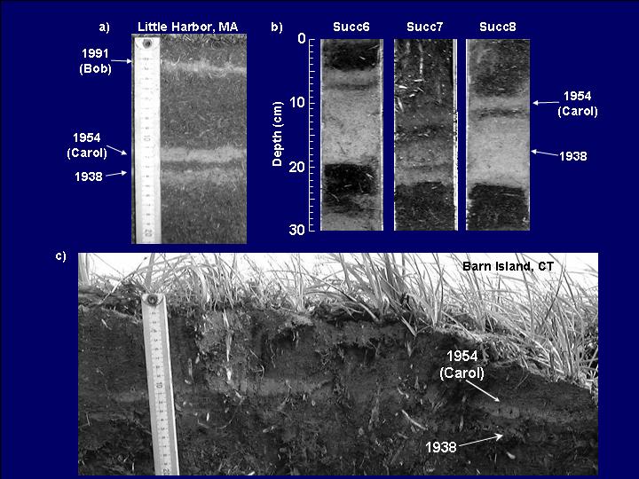
Scientist Jeffrey Donnelly, of the Coastal Systems Group at the Woods Hole Oceanographic Institution (WHOI), is looking closely at the mess left by hurricane storm surges--not the mess left by Katrina on the Gulf Coast, but the mess left in the New York City area. He has found not just one, but at least ten layers of sand left behind by likely hurricanes in the last seven hundred years.

Dr. Donnelly hopes to reconstruct the history of intense storms in the Southern New England and Long Island by looking at the deposits left by land-falling hurricanes and storm surges in backbarrier salt marshes and kettle ponds found at different heights throughout the area. So far, his group has found sand layers that correspond to the known great storms of 1991, 1954, 1938, 1893, 1788 and 1693 AD. Many additional layers indicate prehistoric storms that date back to 1642–1477, 1434–1347, 1316–1257, and even to 1190–1034 AD and earlier.


While considered rare in the New York City area, land-falling hurricanes have likely occurred many times throughout the past ~3500 years. With six severe storms, likely hurricanes, in the past 700 years, the frequency of land-falling hurricanes in the New York City area is equal to that of southern Rhode Island, and higher than that of southern New Jersey. Initial findings suggest that alternating periods of frequent and infrequent hurricane activity have occurred in the past, possibly tied to changes in climate. The times of high hurricane activity in western Long Island are 3500–3050 years before present (BP) and 2200–900 BP, nearly synchronous with high activity observed in the Caribbean and northern Gulf Coast.

Estimates of past storm strengths and frequencies are extremely valuable to researchers trying to tease out the influence of human activities on climate.

Sunday, February 18, 2007

Going in (Great) Circles:

On a spheroid like the Earth, it is a well known fact that the shortest path between two points lies on a Great Circle. What is not so well known is that this same Great Circle also defines the longest distance between those two points. The longest distance is simply the arc going the other way.

So, my question was: "what is the longest great circle route one could fly on Earth and always be over a) land, and b) water?"

Thanks to Google Earth and its Ruler/Path tool, I found the following candidates:

Over Land: Beach near Dong Hoi, Vietnam to Dakar, Senegal - 12,900 km

Over Water: Tellicherry, India to Iliamna Bay, Alaska - 29,000 km

You will note that for the overland route, I did not count small lakes as being over water. The key to this route is threading the arms of the Red Sea and the southern Mediterranean beach near Rafa. If you slightly bend the "rules" and ignore the arms of the Red Sea, you can get a much longer route, Magadan, Russia to the Northern Namibian coastline (Hoarusib Mündung/Delta) of 14,620 km. This route is constrained by the Caspian and Black Seas.

For the overwater route, I did not count very small islands as being over land. Getting around Antarctica is the key to these routes, and threading various narrows. This is where you will have to use the 'path' tool rather than the 'line' because these distances are farther around than the antipodal point. An early candidate of mine was Pulau Dramai, Papua New Guinea to Seminole Shores, Florida - 24, 460 km.

Have at it folks!

Saturday, January 06, 2007

Scrumptious telephony

While discussing the problems we have been having with one of our cell phones, and how we would dispose of the old one, my wife came up with a great idea.

"Why don't they make edible phones? When you are done with it, you simply eat it!"

The more I thought about it, the more it made sense. It's not an impossible goal, although incredibly difficult. There are organic materials out there that do just about everything required - substrates, masking, semi-conductors, phosphorescents, etc. etc.

It might take a while to get the average cell phone to under several pounds of weight, and leaving it in the sun might be a problem, but then there are other benefits: no need to worry about all that personal data on your PDA - a little concentrated hydrochloric in your GI tract would take care of it permanently.

The pathetically obvious advertising campaign for LG's "Chocolate" series telephones (1, 2) would certainly make more sense.

Tuesday, January 02, 2007

Route 66, here we come!

The other day a group of us curmudgeons were lamenting the fact that today's pimply grocery clerks can't mentally figure out the change, and are left helpless when the power goes out. The old standard argument came up about how electronic calculators have weakened our maths skills.

I realized that a similar type of malady has afflicted me, as I have become overly dependent on a different electronic gizmo - the GPS navigation in my car. What should be a basic skill, finding one's way from place to place, is left to a device that has many more ways to fail than one's memory. Many cars are now coming with this option available, and there are many portable units available to install in older cars. More and more people are probably losing their ability to navigate, and becoming dependent on these little devices.

However, in using this amazing technology, I have also come to realize a wonderful benefit. In suggesting several choices of routes to take, it is letting me explore routes I never would have driven on my own, including some beautiful small back-country roads. That made me think that perhaps this GPS nav technology will begin to revive some of the small towns that the interstate system killed off in the late 1950's. Location near a main highway will not be such a necessity for businesses like hospitality, where being 'away from it all' is in fact a plus. Finding any location, business or otherwise, will become much easier.

There has been a lot of discussion in urban planning circles about whether repeated cul-de-sac patterns are more conducive to 'neighbourliness' than strict grid patterns. The premise is that more complex and confusing street patterns discourage traffic flow (enhancing safety for children), and make it harder for criminals to 'case' houses for burglary. The GPS technology of course defeats the non-connectedness of the streets.

In fact, the rise of this technology may also mean that many short-cuts once known only to the locals will be more used, and that many now-quiet streets might carry more traffic. I also wonder whether this new 'accessibility' that GPS nav gives will affect the very design of our cities and their suburbs. It may well also open up areas to developers that until now had been too out of the way for consideration.

Tuesday, November 28, 2006

Life, the universe, and everything:

A recent letter that has come, individually, to almost every program officer in the Earth Sciences Division:

"Mr. Filmer:

I have been a Professional Engineer for over thirty years. I have a BS in Civil Engineering from Michigan Technological University and a MS in Civil Engineering from Michigan State University. I have a broad background of experience and a long-standing interest in rocks and geology.
I have spent several years in puzzling over the process of periodic uplift and subsidence of large areas of rocks that has resulted in the formation of sedimentary rock formations. The simple word ¡§uplifted¡¨ is used extensively by scientists but, even though understanding the process is basic to understanding nearly all aspects of geology; though evidence of the process of uplift is abundant on all of the continents; and though uplift has been the subject of considerable research, concern and debate in the geological research community; scientists do not seem to understand the very basis of the phenomenon itself. It is certainly not well-explained by any scientific hypothesis that is related to the subject. ¡§Confusion reigns!¡¨

I have used engineering principles and analysis; principles of physics, hydraulics, thermodynamics, and mechanics of materials; integrative theory; logical deduction; my own investigations and observations; the sifting of extensive existing data and analyses; physical laws; common sense, experience, the process of elimination, and other problem-solving techniques to study the mechanics of the process. As indicated above, the process is not an isolated phenomenon, but rather is closely related to most aspects of geology. Attempting to do geological research without understanding this basic process is much like shooting in the dark and hoping to hit something.
I believe that I can explain well beyond a reasonable doubt how the process has functioned and, because the topics are closely related, why many overthrusts, ¡§out of order¡¨ formations, mountain chains, continental shelves, discontinuities, and islands exist as they do; why the continents are configured as they are; why there are terrestrial features on continental shelves; why there are land fossils in sea-deposited rocks; why there are tropical fossils in polar regions; why there are fossil similarities of cross-Atlantic sediments; why many of the rock formations were deposited in shallow-sea conditions; why some petroleum occurs where it does; why the Pacific Ocean, the Atlantic Ocean, and the Mid-Atlantic Ridge are where they are; why some of the Earth¡¦s basic physical processes are as they are; and the reasons for the differences between oceanic and continental crust.

In addition, I believe I can resolve the questions concerning continental drift beyond a reasonable doubt, especially as it relates to the concepts of the following which need to be revised or put to rest completely:

?« Plate tectonics, wrench tectonics, surge tectonics,
?« Seafloor spreading
?« Lemuria, Atlantis, Hyperborea, The Imperishable Sacred Land
?« Rodinia, Pangaea, Laurasia, Gondwanaland,
?« India¡¦s ¡§flight and movement¡¨ into Tibet, and
?« The ¡§fit¡¨ of Africa and South America.

I am well aware that the above suggests much too broad of a scope for a single research project, but the fact is that the process of uplift and subsidence is such a very basic (but misunderstood) factor in the Earth¡¦s history that all of the above topics are actually very closely related to the process, each in its own way, and as such are an integral part of the explanation of it or it explains them. The pieces fit together like a giant jigsaw puzzle. Also, a large part of the proof of my explanation is the extent to which it embraces the findings of other researchers regarding these topics. I may not have extracted the same conclusions from the basic data they have gathered, but my explanation seems to be in accord with much of previously accumulated data that I have studied and with physical reality and I believe it demonstrates well beyond a reasonable doubt the validity or invalidity of the conclusions they drew from their research as well as my conclusions.
This study has the very probable potential of completely changing long-standing ideas as to the Earth¡¦s history and some of its processes.
Because of its wide-ranging applicability and the close correlation of the above-listed topics, it is expected that the results of this research will revolutionize the present state of knowledge in the field. All who study any aspect of the processes that have affected the Earth from Precambrian times to the present will benefit from this study.

It will shed new light on the basic processes which formed sedimentary rocks and subsequently elevated them which should aid in further discovery of natural resources, including offshore oil and gas, a very important economic activity in the world.

The broader impacts of the study are that it will contribute significant information concerning an obscure period and the substantial increase in knowledge will provide the basis for major revisions in the scientific understanding of prehistorical processes. The study results are multi-disciplinary and will have a profound effect on the research fields of Continental Dynamics, Archaeology and Archaeometry, Geophysics, Hydrologic Sciences, Petrology and Geochemistry, Tectonics, Geography and Regional Sciences, Geomorphology and Land Use Dynamics, Marine Geology and Geophysics, Paleoclimatology, as well as Sedimentary Geology and Paleobiology.

Researchers who are working on a broad range of problems worldwide will benefit directly and measurably from the results. The results of this research will provide future investigators with a solid integrated foundation for further geologic studies rather than a jumble of nebulous, ill-founded hypotheses. This study will provide members of the scientific community with a scientific and structured understanding of their geologic environment that is 99% certain rather than being 90% nebulous. It also will provide an educational resource for students as they study geology such that they can appreciate the relationship among Earth's development, geologic events, and the history of life.

My questions are: I have spent literally thousands of hours researching this subject and puzzling over what I have observed and the meanings of the findings of very reputable researchers attempting to put the puzzle pieces together. Is there any way that the time I have spent on this research can be included in a grant? Can a grant be awarded for a set amount based on attainment of a specific goal (explanation of all of the above-listed
phenomena) rather than being based on time spent after award of the grant?
Considering the knowledge, skill, and ability required to assemble the giant jigsaw puzzle, the great amount of time spent in doing so, and the apparent inability of anyone else being able to do so, would it be reasonable to apply for a grant of $4,000,000 as a flat rate consultant fee? I realize that that is a lot of money for one research project, but on the other hand, a lot more has been spent on unproductive research related to the listed phenomena and this should help your organization avoid spending a lot more on research that is based on a poor foundation.

Thank you for your consideration of this matter.

**Name and address removed for safety reasons**


At $4 million, the solutions to all these quandaries are a bargain. What do you say, fellow taxpayers?

As required, I sent a polite reply outlining the application procedure. He might well have *the answer,* but here at NSF, everyone gets in line. Even Nobel Prize winners.

Now, back to being 90% nebulous.