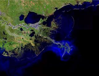
This image shows quite clearly that the levees stopped the deposition of sediments in the proximal distributary area, and allowed them to drop out only at the far end of the river - the crows foot extending ever-further into the Gulf. That, of course, was one of the ingredients in the disaster - river deltas depend on an equilibrium between the sinking sediments and the yearly piling on by floods to maintain a constant height above sea-level. As soon as you stop delivering sediment, the surface will slowly start to drop, and you will eventually be below sea-level, and you will have to start building dykes, or levees.
I am in Mexico this week, in the town of Puerto Vallarta. A much smaller version, but many of the same ingredients - the shore is built on a set of sandy dunes that buffer the wetlands behind from many of the storms that weep in off the Pacific. The river deposits sediments in the wetlands, and the sea delivers sand to the dunes, and there was a slow dance back and forth as the shoreline moved back and forth over thousands of years. Until modern man, that is.
With the construction of spillways to control the meandering of the river, sediments are no longer delivered to the wetlands, and they are slowly sinking. Large housing developments are being put into these wetland areas, replacing the farms. With the construction of beach front resorts and sea walls, beach erosion results. The end result: a large storm will eventually come through here, and there will be no beach dunes to stop the storm surge from flooding the housing developments.
Mexico does have environmental laws that prohibit exactly this kind of situation. But the Federal laws have very little weight here, where the Mayor and the town's workers are interested in the money injected into the local economy by real estate development on the shore and in the wetlands. As always, it is the social context that makes it a very complicated situation - the environmental economic costs of this pattern of development are not expressed in any tangible way, and won't be until disaster strikes.
No comments:
Post a Comment