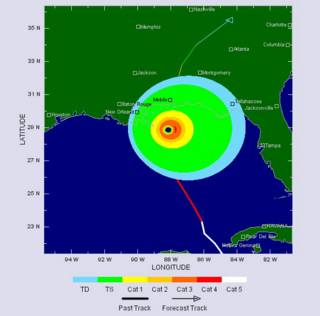
Ivan windfield predicted 12 hours out by TSR.

Well, the moniker "Ivan the Terrible" was fairly predictable. I hope we don't get to "Vlad the Impaler" for two reasons: first, the imagery of something worse than Ivan is hard to imagine, and second, the name Vlad would mean that we would have had twenty-two named storms!
Here's an updated set of my favourite hurricane links:
- TSR, the insurance industry's model
- NOAA's National Hurricane Center
- General satellite imagery
- Hurricane Hunters:
- Water Vapour channel loop from NOAA (won't always be Ivan...)
- Skeetobite Weather pages
- Naval Research Labs Tropical Meteorology
- A forlorn webcam loop pointing out to sea in Mobile, Alabama
I also found two really nice movies by NASA Goddard showing how hurricanes feed off warm water. You will need a fairly robust connection to download these quickly, so beware if you are on dial-up... The first example shows hurricanes Fabian and Isabel (1Mb MPEG-1) moving across the Atlantic and Caribbean in 2003. The color represents sea-surface temperature, with blue colder than orange. Note how the passing of the hurricanes leaves a cold wake as the hurricanes feed off the warm waters.
The second example shows an interaction between tracks, as the 1998 hurricanes Bonnie and Danielle (6Mb QuickTime) interfere with one another - if you watch carefully, you can see that Danielle is weakened as she passes over water that has been cooled already by Bonnie (it's harder to see, but if you go back to the first movie, you will see that Isabel is not weakened much by crossing Fabian's track because enough time had passed that the track had mixed and warmed up again).
This is also why hurricanes weaken as they approach land - there is simply not enough water volume to feed them as the shallowing waters begin to starve them even before they make landfall. You can deduce from this that an approach path over a broad shallow shelf will weaken an storm more than an approach over a narrow steep shelf. Even then, if a warm current flows near-shore, it can strengthen a storm - something that is expected to occur for Ivan.
No comments:
Post a Comment