I was lucky enough to complete one of my lifetime quests last week. I got to see Angel Falls. And I want to go and do it again, this time on foot, from the top. This post is a series of pictures that will focus in on this remnant of an ancient landscape.
The first diagram here shows South America, as seen by the Shuttle Radar Topography Mission (SRTM). Color indicates height, as on most maps. Shading is controlled by radar reflectance, a rather complicated topic I will leave for another post. The red box is the area blown up in the next map.
 If you click on the picture itself, you will go to an index page where you can download the full resolution picture (a whopping 7.8Mb JPEG, 7,200x10,886 pixels).
The next picture focuses on the Guyana Highlands area outlined in red above - a set of enormous mesas that rise 2,000 to 3,000 feet above the savannas of Venezuela, Guyana and Brazil. The mesas, known as tepuis, were formed over hundreds of millions of years as rivers cut into a thick layer of pink quartzite sandstone, itself as old as the Precambrian. The contrast between the dark green mantle covering the tepui tops, the sheer pink and black cliffs, and the lighter green to brown savannas is stunning. Most of the higher tepuis in this image have never been visited by a human. They are almost impossible to get to, even by helicopter. There are very few places left on Earth like that. The red circle outlines Auyán Tepui, from which Angel Falls ...fall.
 Again, if you click on the picture itself, you will go to an index page where you can download the full resolution picture (1,900x1,070 pixels), which includes a version of the best known topography before SRTM was flown.
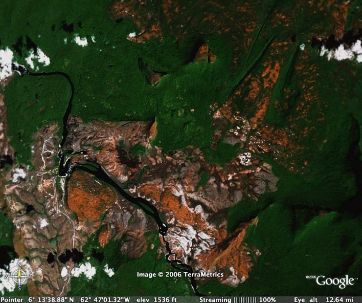
Now we switch to Google Earth for the next inwards zoom, and focus on the Auyán Tepui area itself. You can match the heart-shaped area in the center of this picture to the shape seen in the above radar picture to orient yourself. The red circle here indicates the central canyon through the tepui, cut by innumerable waterfalls that line the canyon walls. The red rectangle outlines the next zoom, into the Canaima area where flights land.
 If you click on this picture, you will get a larger version without the red markings.
In this picture of the Canaima area, the red circle outlines a tepui I will come back to below. The red rectangle is an area that I photographed obliquely from the air, shown below.
 Again, if you click on this picture, you will get a larger version, without the red markings.
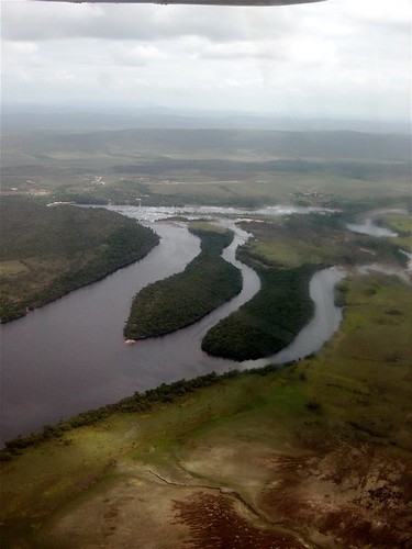
In the aerial photo below, looking roughly West, you should be able to match up the channels of the Carrao River with the "tines" visible in the center-top of the red rectangle area. You can just make out the Canaima (CAJ/SVCN) landing strip in the oblique aerial photo, and the strip is quite clear in the center-left border area of the rectangle in the Google Earth photo. The landing strip was crushed gravel - FOD city, which made for a noisy landing and take-off.
 And clicking on this picture will take you to my Flickr page for it...
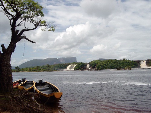
This next photo was taken from the Western shore of the Canaima Lagoon (actually still part of the Carrao River) at the "elbow" to the left of the tines, looking North-East towards the red-circled tepui I referred to above (this is called Karavaina Tepui). If you look carefully, you can see that there are lower, sloping tepuis to the left and right in this picture, which can also be made out as triangluar blocks in the Google Earth picture above (they are known as the Nonoy and Topuchi Tepuis). The waterfalls here were spectacular, even for being the end of the dry season. There is enough space behind them for multiple groups of fat tourists. The water is quite red from the tannins, and the "beaches" in the area are distinctly pink from the rose quartzite.
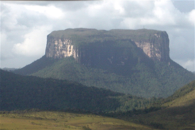
This next picture is an aerial photo of Karavaina Tepui, typical of one of the lower tepui structures - sheer walls surrounded by a debris pile, with a relatively, but not completely flat, top. Taller tepuis will have double or triple stacks of these cliff-debris combinations. Most of the tepuis have extremely rough, or karstic terrain on their tops - highly dissolved rock full of caves and pits. This leads to some amazing places for caving, but the truly marvelous oddity is that this type of terrain usually occurs in calcareous stone like limestone. These layers have been here for so long (longer than almost anywhere else on Earth) that water has been able to perform its erosive magic even through quartz sandstone. This landscape has escaped the violence of tectonics and lain still since before the dinosaurs were a twinkle in Nature's eye. The isolation from the surrounding territory has also allowed the tepui tops to develop their own peculiar ecosystems - some of them have their own specific species of plants, frogs, etc. Here's a nice intro with some depth to it...
But this isolation might also be the ecosystems' undoing - as global warming occurs, species usually adapt by moving upslope, following the isotherms. On a tepui, there is literally nowhere to go. However, I note that given the length of time these structures have been here - this type of thing has happened before. Here's a group that has just started looking at this issue - I plan to meet one of them later this year in Beijing. It is this 'splendid isolation' that led many biologists in the late 1870's (just after Darwin's "Origin of the Species" and "Descent of Man" were published) to speculate that the tepuis might harbour species long extinct elsewhere - perhaps even dinosaurs. An expedition in 1882 led by Everard Im Thurn finally ascended to the 9,000 foot summit of Roraima Tepui, and Sir Arthur Conan Doyle supposedly attended one of the lectures the expedition gave on their return, and his book "The Lost World" was (probably) the result. From there, Michael Crichton and Steven Spielberg moved all this mythology northwards and onto Pacific islands off the coast of Costa Rica.
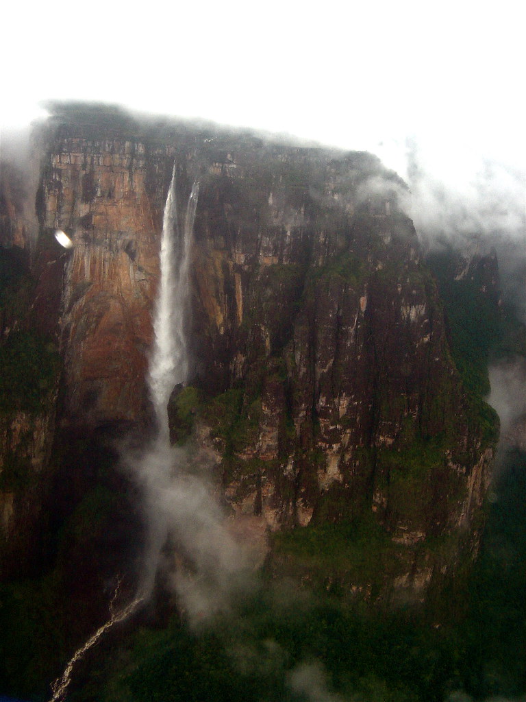
From Canaima we flew in a 15-seater high wing into the canyon of Auyán Tepui, sandwiched from below by fog, and above by low stratus clouds that covered the top of the tepui. All we could see was the sides of the canyon, which were lined with waterfall after waterfall, spilling the rains that fall on the moister tops into the drier valleys below. The pilot announced that they were not sure it was clear enough to see the falls themselves, and an audible groan cut through the drone of the engines. But my wish was strong enough to part the clouds, and suddenly there it was. For a few seconds we showed our plane's belly as the pilot put us into a very tight turn inside the canyon, and both sides of the aisle had seen the unimaginably slow drops of water falling 3,212 feet -- much like Jimmy Angel and his crew did in 1933.
 I sat happily on the way home, smiling as I gazed out over the "Great Savanna," and the slowly hazier air as we flew back North into the "real" world.
Additonal Links:
1 comment:
Wow, I am speechless and jealous.
How wonderful.
Post a Comment