Jody works mostly in the Pacific (where most tsunamis occur, as you will have read in one of my previous posts), looking at the layer of rubble, gravel, sand and silt that tsunamis leave when they run up onto the shore. By digging pits in various spots, and looking at these layers, one can build up an idea of how often these events occur. Once you find a tsunami deposit, you can do a series of pits progressively farther from the shore to see how far the tsunami went inland - in this way she is trying to see where they occurred, how often, and how severe they were. Most of her work has been in the Cascadia region of the US (Washington state), and on the Kamchatka peninsula, in the Russian far East.
Here is a photo taken by one of Jody's grad students, Bretwood Higman, while in Sri Lanka on the tsunami survey team:

Tsunami deposit in Sri Lanka (photo credit: B. Higman)

In this case, a 30 cm layer of lighter-coloured sandy tsunami deposits overlies the previous darker-coloured soil surface. Jody showed similar sections from the West coast with grey tsunami deposits sandwiched between the pre-existing soils and the later, younger soils on top of them (in the above photo, the younger soils overlying the tsunami deposit have not been deposited yet, since the tsunami occurred so recently).
As you might imagine, Jody is in great demand these days, and is in Washington DC to speak at a Smithsonian press event tomorrow morning at the Willard. She has been dealing a lot with public misconceptions about tsunamis, and she spoke to us about the threat to the Atlantic coast.
One item she mentioned was the threat from the cataclysmic collapse of the Cumbre Vieja volcano in the Canaries, much quoted in the press, and parroted by me here. It turns out that the model producing a 25 meter high wave on the East coast is a model by Steve Ward at UC Santa Cruz (you can see a set of Steve's powerpoints on landslide generated tsunamis here, including diagrams of the Cumbre Vieja predicted wave). Of course, disasters make for good news, so the work by Steve on the tsunami and by Bill McGuire of the Benfield Greig Centre in the UK on the collapse of Cumbre has been played up a fair bit by the press.
This much, at least, is still science. On to the outright fakery portion.
Immediately after the Sumatra event, all sorts of photos emerged purporting to be of the tsunami. Fortunately many of them were real, which can help educate people on what to do in this situation, and to document what happened. Others were outright fakes that only serve to propagate misconceptions. Jody used the following example in her talk that I had seen floating around on the internet, and which I had tried to stamp out as well as I could by telling people it was a fake (the red letters are mine, more below on that...).
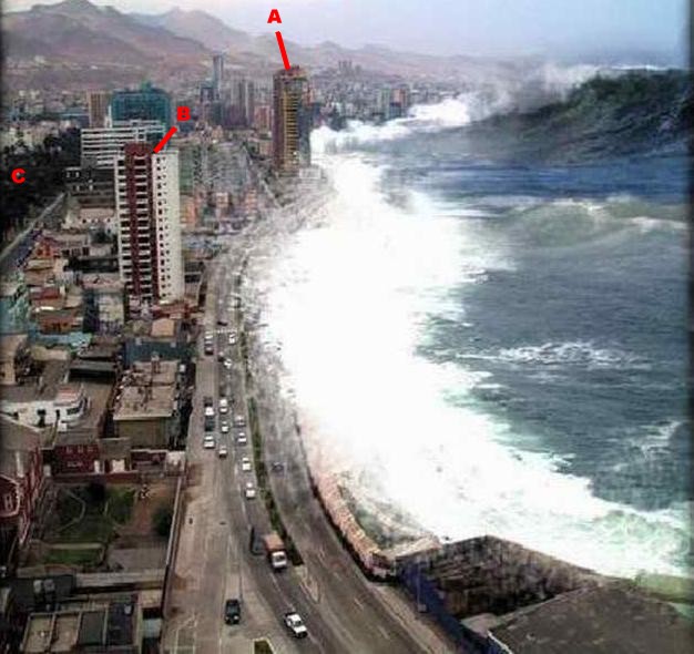
Fake tsunami photo
I hadn't paid much attention to it in the last few weeks until I saw it again, up on the big projection screen, and it screamed out "South America" to me. I don't know exactly why, but something in the architecture, setting, etc. just made me think the city was in Latin America. At first I thought it was Bogota, because one of the buildings looks somewhat like the Tequendama Hotel, and a far off building looks like the Avianca skyscraper, but there were still several things wrong for the skyline to be Bogota.
A quick search on Snopes.com identified this tsunami picture as a known fake - and pointed to a what they claim as the source for the original photo of the Antofagasta skyline at World City Photos:

Lantadilla photo, looking South
Sure enough, this photo by Christian Lantadilla is of the same scene. However, I do not think this is the photo that was used in the fake.
To confirm this, I did a bit more searching myself. First, are the two photos Antofagasta at all? Sure enough, there is a giveaway photo of the Antofagasta waterfront here, in an artcle in Realidad, a Chilean magazine. Here is the photo:
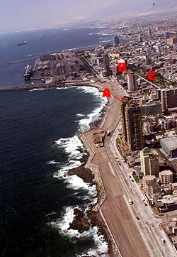
Realidad photo, looking North
I have added letters to identify several landmarks. The fake tsunami and Lantadilla photos are taken looking South, with the city to the left. The Realidad photo is taken looking to the North. The letter "A" marks a tall building with yellow and red bricks with a characteristic roof shape. "B" indicates another building with characteristic red and white brickwork, while "C" indicates a park area.
But back to the difference between the tsunami and Lantadilla scenes of Antofagasta. As can be seen in the Realidad picture, it is very probable that the other photos were taken from the dark building at the end of the road just to the left of the "B." My guess is that these two photos were taken from different floors, at different times.
First, look at the mountains and the air and light surrounding them. The lighting and visibility is totally different between the two pictures, and this is not something easily changed with image processing - nor would there be a motive for the person faking the tsunami to put the work into changing the apparent visibility. The Lantadilla photo was taken on a clear, sunny day, while the fake tsunami background was taken on a more overcast, flatter lighted day. On the street next to the park there are tree shadows in the Lantadilla photo that are not present in the other (there is also a vehicle on this street in the tsunami picture that is not in the Lantadilla photo).
Second, the parallax in the photos is different. My guess is that the fake tsunami photo was taken from higher up, and more to the West (seaward), than the Lantadilla photo. It's difficult to tell with the images here, but if you download the originals, you can tell that the red & white brick building shifts ever so slightly against the more distant buildings behind it when you alternate between the two photos. You can see more of the roof (upwards motion) in the fake photo, and the red brick stripe moves leftwards against the building in the background (seaward movement of the observer). In this area there are several other inconsistencies - a possible reflection in the blue-glassed building that is either not there or due to intervening construction between the two photo times, and construction or modifications on the grey building that extends from the red & white to the park area.
I'm convinced that a) the tsunami photo is fake, b) the background is Antofagasta, and c) the fake was not made with Christian Lantadilla's photo.
In the end, what is wrong with the fake photo's water? Why couldn't this be a real tsunami in Chile? First is the scale - look at the height of that wave - it's taller than some of the apartment buildings. Only a major asteroid impact would give that kind of height. A tsunami is a low wall of water that simply keep on coming - sort of like a step function, and not a tall curling wave. Second, the scale of the features in the wave is wrong - look at the ripples and the foam - they just look wrong compared to the size of the cars. Now - there have been tsunamis in Antofagasta, with 1995 being the most recent - but they NEVER looked like this. This is not what a tsunami looks like - at a distance, tsunamis look harmless enough for you to simply stand there and watch. ...and take photos. ...and wait. ...and film. ...and suddenly realize that there is a river of seawater coming for you!
I had to chuckle as I was putting this post together: "Realidad" is Spanish for reality, or truth.
No comments:
Post a Comment